A lot of watching….

Water sampling in deep water is a slow and  tedious process. The conductivity-temperature-depth (CTD) instrument with water sampling carousel in a rosette pattern is lifted in the air by pulling up on the wire. A large metal frame, called an A-frame because it looks like the letter A, then swings out over the water and the instrument is lowered in. The following two to three hours are spent lowering the CTD at 50 meters (about 165 feet) a minute to near the bottom (~1500 meters, or roughly 5,000 feet deep) and then raising the CTD at 30 meters (about 100 feet) a minute back to the surface. The ascent is punctuated with stops to collect water samples, and turning the instrument off and then on adds a little extra time. Two to three hours of watching a computer screen for a scientist, and three hours of watching the winch controls for a crewman,  is a  typical CTD deployment.
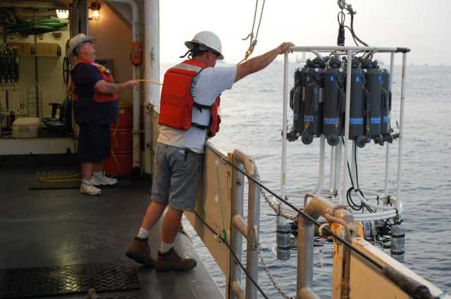
CTD being deployed

General Vessel Assistant Carl Coonce and Skilled Fisherman Jon Jarrell deploy a CTD (conductivity, temperature, depth) rosette onboard the NOAA Ship Henry B. Bigelow. The Deepwater Horizon site is visible in the background. The CTD device detects how the conductivity and temperature of the water column changes relative to depth. Bottles mounted on the rosette are also used to collect water samples at different depths. Credit: NOAA.

The weather has been so calm that deployment and retrieval has been easy. The instrument comes aboard in reverse of how it went out. Once on board, various samples of water are taken from the bottles for analysis.

During the post-kill period when we were not permitted in the wellhead zone, we took on a gas chromatograph (GC), an instrument to separate and analyze chemical compounds in a sample,  and a scientist from the NOAA Ship Gordon Gunter, which was returning to port after working on the Deepwater Horizon incident response.   We also met the NOAA Ship Pisces and transferred our winch repairman to that ship, as the Pisces was having problems similar to those  we had, and getting the repairman aboard the Pisces as soon as possible would them save a lot of time.

The onboard gas chromatograph (GC) analyses water samples for the volatile organic compounds that are found in oil. This near-real time capability allowed us to know what we were sampling, unlike the weeks to months it will take to get the results from the other samples we have collected that will be sent to a laboratory onshore.  The results of the GC analyses were pretty clear:  no volatile organics at depth.

At a few stations, however,  we found toluene near the surface in low concentrations.  Toluene is a colorless,  flammable liquid obtained from petroleum or coal tar and used in fuels. The source of this contamination was unclear. If it was from oil, we would expect other volatile compounds to be present. We ran a number of control samples: rinse water only, dropping vials on the deck, holding water in bottles and then extracting. All of these controls contained no toluene, so at this point the source of trace amounts of toluene in surface samples remains unresolved.

The other water samples – the ones to be shipped off to a laboratory – will be analyzed for polyaromatic hydrocarbons (PAHs). These samples and their analyses will provide a much clearer picture of how much oil is left in the area around the wellhead. We were sampling within 10 kilometers or km (about six miles), and were part of a research fleet that had numerous ships sampling around the area of the well from 15 to 60 km (roughly 10  to 40  miles) distance.

As we neared the end of our cruise, we had made almost 30 CTD casts  – or more than 60 hours of scientists and crew watching the computer screen and the winch controls.

Jon Hare
Chief scientist

Kill and Kill Again

August 8, 2010

NOAA Ship Henry Bigelow at the wellhead

The NOAA Ship Bigelow entering the wellhead area to conduct an acoustic survey over the wellhead. Picture taken from DDIII, the rig drilling the relief well.

The days during and after the “kill” operation have been busy. During the operation we were not granted access to the wellhead region. The last thing anyone needed was another ship working through the area, distracting from the operation itself. We patiently circled outside the 1500 m looking for acoustic evidence of material escaping the wellhead region at depth and visual evidence of oil on the surface. We saw no acoustic evidence at depth, but the data were sent to acoustic experts on shore for more thorough analysis.

We did observe some oil on the surface: 1 to 2 foot diameter areas of sheen, one larger patch and numerous little whisps. Some of this was likely from all the ships operating in the area, but some may have been from the wellhead. Our efforts to collect these little spots were largely unsuccessful.
We used this time to prepare for water sampling. Our water sampler is twelve 5 liter bottles that go into the ocean all open on a carousel. The sampler is lowered to depth and then raised. Bottles are then closed at certain depths. Our problem was that sometimes the bottles would not close.

The electronic control from the ship goes through a number of steps before reaching the carousel to close the bottles. The computer running the whole operation is in a lab on the ship. This computer is connected to a deck box that contains the “brains” of the water sampler and other equipment on the carousel. The deck box is connected to slip rings on the winch, and through these slips rings to the wire used for lowering the carousel. The winch has a large drum with wire wrapped on it. To lower the equipment, the drum spins paying out wire. The slip rings allow for the electrical connection to be maintained between the deck box and the wire while the drum turns – one of many ingenious technical solutions that makes sampling the ocean possible.

The wire has the electrical wires inside and the weight bearing part outside. Think of it as normal wire, with copper inside and insulation outside. But in addition to insulation there is another layer of wire that hold thousands of pounds of weight. At the end of the deployment wire there is another ingenious solution to a problem – how to get the inner electrical wire out from the center of the weight-bearing wire while preserving both the electrical connection and the weight-holding capability of the outer wire.

The poured termination is the solution. The whole wire is passed through a steel fitting and the electrical wires are taken to the next step. Metal is then liquefied and poured into the fitting. Once the metal solidifies in the fitting you have a weight-bearing termination with the electrical wires coming out. These wires are then connected to the wires that connect to the carousel. This splice of wires is also special because it must be waterproof even at the extreme pressures of 1000’s of meter (see http://sssg1.whoi.edu/sssg/termination/termination.html for more information).

Somewhere in this electrical chain, we had a problem; it wasn’t that the carousel didn’t work; it worked most of the time, but not all of the time. Intermittent problems are the hardest to troubleshoot.

We changed everything we could see, with no luck. However, we found that if we turned the deck box off and then on again, everything would work for a while – usually long enough to collect all the water samples we wanted. The problem wasn’ fixed, but we had a work around.

We heard reports that the “kill” operation was for “all intents and purposes was successful.” We didn’t quite know what this meant, but soon after we were granted access to survey over the wellhead. Over the next three days we made more than 25 passes with our acoustic instruments. Although the acoustic signatures over the wellhead appeared lower, there was much more background noise. This noise made preliminary assessments difficult. We transferred data ashore for more thorough analysis.

We also were given the opportunity to start water sampling under the conditions that we could return to the wellhead on short notice. Working with our shore-side support, we decided to sample a set of stations 2.5, 5 and 10 km from the wellhead. With our water sampling carousel mostly working we started making casts.

Jon Hare
Chief scientist

Samples Off, Water On, Monitoring Continues

Our acoustic monitoring efforts continue. Since the beginning of the static kill operation, we have not been able to work inside 1,500 meters (about 4,900 feet or just under one mile). There is no clear passage through the area with all the ships, and the ‘kill’ operation doesn’t need us driving through the middle of the action.

Most of the ships working in the wellhead region are using dynamic positioning (DP), in which the ship’s propellers and thrusters  hold it in a constant position. In fact, it is a little strange to watch all these ships from outside the circle and realize that none are moving even as the wind and currents move around them. It is like  a village of 20 houses out in the country with very few other people and structures around.

This morning we moved samples from our ship to a supply boat for transport to shore. The water samples collected by the CTD were labeled and stored in a walk-in refrigerator onboard. The hydrocarbon analyses need to be conducted within seven days of collection, so we need to transfer the water samples to a vessel that takes them ashore to a truck that then takes them to a lab for analysis. The supply boat pulled up along-side and offloaded two NOAA Natural Resource Damage Assessment (NRDA) sample representatives. These people met with our onboard NRDA rep and data manager and reviewed all the documentation: the sample numbers, locations, and depth. Once everything was in order, the custody of samples changed from our NRDA sample rep to the sample reps on the supply boat. This formal chain of custody is necessary because data from the samples could eventually end up in a court of law. As the supply boat pulled away, I looked at my watch – it only took us 1.5 hours to transfer four coolers of samples.

The Cajun Canyon Express alongside the Henry B. Bigelow for a supply transfer.

Our next “chore” for the day was getting more freshwater.  As I noted in an earlier post earlier, the ship cannot make water in the incident area, so we only have the water we left Key West with, and we’re getting low even with conservation measures. We ordered some water, and the water boat just pulled along-side. They will transfer 8,000 gallons of freshwater to the Henry B. Bigelow at a rate of 110 gallons per minute in about two hours.

We are getting our “chores” out of the way so we can be ready to enter the wellhead area once the “kill” operation is completed. The mud injection was completed yesterday, and they are currently cementing the well. From the surface it looks the same; about 20 ships sitting absolutely still five miles away. But I am sure there is a lot of activity under the surface.

Until we are able to enter the well head area again, we will continue water sampling and acoustic monitoring of the outlying areas.

Jon Hare

Chief Scientist

1:30 AM and the Gulf is Still Beautiful

It is a beautiful day. If you weren’t looking toward the 20+ ships and couple of rigs a kilometer away, it would seem like another hot, sticky summer day on the Gulf of Mexico.

I worked in the Gulf in the mid-1990s on the NOAA Ship Chapman and the late-1990s on the R/V Pelican. I remember long stretches of calm days, blue water (not a deep blue, but a light blue), and marine life: dolphins, whales, tuna, and more. I have seen all these things in within 1500 meters of the wellhead over the past three days. The release of millions of gallons of oil is an environmental disaster, and the problem is still with us. But even so, the Gulf of Mexico is still beautiful.

We are continuing our acoustic monitoring in the area around the wellhead. We have made 20+ passes over the wellhead in the past two days. From our cursory examination of the data and from the acoustic experts onshore, there has been very little change in conditions. There are acoustic returns in the water column – likely from methane gas – but the magnitude has not increased. The wellhead area is closed now for the static kill and it will be interesting to see what the acoustic data shows when we get back into the 500 meter zone.

Last evening, we started our water sampling effort. We cannot work inside the 1500 meter zone at night and we have used this time to acoustically map much of the area between 1500 and 3000 meters. Our plan last night was to go back to two areas of acoustic returns outside the wellhead, remap these areas, and collect water samples.

We are interpreting these areas as natural seeps – areas where hydrogen sulfide, methane and other hydrocarbon-rich fluid ‘seep’ into the ocean. We ‘see’ seeps as areas of acoustic returns that extend into the water column from the bottom. Some of these areas are persistence; identifiable every time we cross over them, while others are intermittent; they are sometimes there and sometimes not.

We made two conductivity, temperature depth casts (CTD), one to 1000 meters and the other to 1400 meters. A CDT instrument measures the temperature, conductivity, and depth through the water column. Conductivity is converted to salinity – how salty the ocean is. Temperature and salinity are basic oceanographic variables that say a lot about the source of water sampled.

We also have a dissolved oxygen and a color dissolved organic matter sensor. Obviously, the dissolved oxygen sensor measures oxygen in the water. The color dissolved organic matter sensor provides a measure of how much oil there is in the water. Two of the features that have been described for subsurface oil are an increase in colored dissolved organic matter (dissolved oil) and a decrease in dissolved oxygen; the argument being that bacteria are using oxygen to break down the oil.

Water bottles on the CTD can be used to collect water from specific depths. If we see a layer of water with increased color dissolved organic matter and decreased oxygen, we can close a bottle, bring the water to the surface and prepare the water for chemical analyses. The measurement of dissolved oxygen uses a Winkler titration and these can be preformed on the ship. The measurement of oil requires a gas chromatograph, which we do not have onboard. The water is poured into specially prepared bottles, put into a big walk-in refrigerator and then transported to shore in a small boat for analysis.

The first CTD cast was made over an area of blue water; no acoustic evidence of seeps. Unfortunately, we had problems with the winch and the CTD was not deployed all the way to the bottom. We did, however, collect water as the CTD was brought back to the surface. Once the CTD was on deck, the water chemistry team descended on it,  and collected the water from the bottles for the dissolved oxygen analysis and oil analysis.

The second cast was made over an area of a seep. The presence of the seep was confirmed using acoustics and then the ship tried to sit right on top of the location for the 2.5 hour CTD cast – it takes a long time to lower a CTD a mile and then bring it back. The ship drifted in and out of the seep, but we did get the CTD through the acoustic signature of the seep. Once on deck, the chemists descended again, and oxygen and hydrocarbon samples were taken.

We then moved to other seep location and conducted more acoustic surveys to pinpoint the location for CTD sampling tonight. The sun came up just as we were completing our acoustic survey, and we returned to the wellhead site. Since then, we have been circling all day monitoring the perimeter for evidence of leaks from the well (we have not detected any). We are also waiting for our chance to survey over the wellhead to evaluate the success of the kill operation.

Transit Days: Slow speeds, fast action

Submitted 31 July 2010

Transit days always go slowly, even with drills and science prep. Our trip from Key West to the wellhead area is 39 hours, which means all 24 hours of Thursday 29 July was spent traveling at about 14 miles per hour. Try driving that speed in your car for more than a minute; it is slooowwww.

But for a ship pushing through water, the speed is not bad.

Much of the 24 hours was, however, filled with activity – not shuffleboard and skeet shooting, but a fire drill, an abandon ship drill, a review of science operations and safety procedures, breakfast, lunch and dinner.

After lunch, a fire drill is sounded on the ship’s alarm: kind of like an electronic pulse. When the alarm goes, scientists are required to get their life jacket and survival suits and report to the conference room on the 01 deck. We then report our presence to the bridge so that the officers know we are all ok and know where we are. We then wait while the crew and officers fight a mock fire.

The fire drill was followed by an abandon ship drill. You take your life preserver and survival suit to the back deck and report to your life raft leader. A long-sleeved shirt and a hat are also required to help protect you from the sun. The officer-in-charge announces the distance and direction to the nearest land. For us it was a beach town in Florida about 150 miles away.

Crew member zipping up the bulky survival suit

Survival suit training drill aboard the Henry Bigelow, July 31, 2010 en route to the Deepwater Horizon oil spill area

Then everyone needs to put on their survival suit. You empty it from the bag, put your feet in, get your arms in, and zip it up. After you get the “all-clear” from the officer-in-charge, the suit comes off and is rolled up and put back in the bag. You need to put it away neatly, so if you really do need it, you can get it out and get it on.

After the abandon ship drill the scientists met on the side sampling station to talk sampling logistics. Working in the vicinity of the Deepwater Horizon MC252 site adds some new steps to our usual sampling protocol. Basically, we are treating the equipment and samples as contaminated with oil, even if they are not. Our approach is to be safe and to take reasonable precaution. We actually ran through these operations twice to make sure that everybody had the drill down.

Typically, we put our instruments in the ocean, lower to depth with the ship’s winches, and then retrieve. Here, we need to first clear oil from the sea surface with a fire hose. Then the equipment gets deployed.  Before hauling it back onboard, the sea surface needs to be cleared again. Once onboard, the equipment is wiped down with adsorbent pads. Water samples are then taken for dissolved oxygen and hydrocarbons, but the people taking the samples need to pass them to others for processing and analysis.

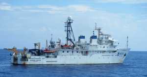
NOAA Ship Gordon Gunter underway

NOAA Ship Gordon Gunter underway

We also passed the NOAA Ship Gordon Gunter. She was doing a conductivity, temperature, depth cast on her way back into Key West after conducting some marine mammal work and helping to monitor conditions around the wellhead . They were near our trackline so we drove by and gave a wave.

And that was our day. Transit days always go slowly.

Jon Hare

Chief Scientist

Bigelow Underway, Looking for Subsurface Oil in Gulf of Mexico

Submitted July 28, 2010

We left Key West today onboard the NOAA Ship Henry B. Bigelow at 1800 (6PM) after a whirlwind of planning, traveling, loading, setting up and stowing supplies and gear.

The Bigelow usually works on the continental shelf and slope between Cape Hatteras, North Carolina and Nova Scotia, Canada. In response to the Deepwater Horizon MC252 incident, she was dispatched to the Gulf of Mexico to assist in NOAA’s restoration and response efforts. She left on 18 July for the trip south and many of the scientist met the ship in Key West rather than making the nine-day trip down the east coast.

Our sailing represents the culmination of three weeks of intense planning to get the ship from Newport Rhode Island to the Gulf of Mexico and to outfit the ship with scientists, equipment, and supplies for acoustic monitoring, oceanography, water sampling for dissolved oxygen and hydrocarbons, and oil droplet size enumeration. In subsequent posts, I will describe these activities in more detail.

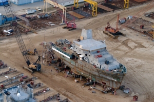
NOAA Ship at the shipyard, under construction

NOAA Ship Henry Bigelow under construction at VT Halter Marine

The Bigelow is a relatively new, state-of-the-art fisheries survey vessel. She was launched at VT Halter Marine in Pascagoula, Mississippi on 8 July 2005. In a sense her return to the Gulf of Mexico and to Pascagoula during our cruise will be a five-year homecoming for the ship.

While in the Gulf, we will use the Bigelow’s acoustic systems to detect seeps of gas and oil from the seabed and from the wellhead. We will also deploy equipment to near the bottom (~2000 m or 6500 ft) using the Bigelow’s oceanographic winches. The Bigelow can carry 35+ people, approximately 5 officers, 15 crew, and 15 scientists. This may seem like a lot, but all the people have different jobs: ship drivers, engineers, deckhands, cooks, oceanographers, acousticians, and water chemists among other jobs.

Because we ramped up very quickly for this cruise, most of our supplies were sent from the northeast directly to Key West, where the ship docked at the Coast Guard base.  Scientists converged on the ship from Louisiana, Florida, North Carolina, New Jersey, Washington, Rhode Island, and Massachusetts. Truckloads of supplies awaited us that needed to be loaded and then stored. Even though we are not expecting rough weather, everything needed to be tied down because you never know when the seas will pick up, throwing unsecured items around.

Several meetings were held during our first full day aboard ship. Because of the unique nature of working in the vicinity of the Deepwater Horizon MC252 Incident site, the Commanding Officer, Commander Anne Lynch, led an all-hands meeting (ship’s officers, crew and scientists). She emphasized our first priority was safety: safety of everyone on board and safety of the ship. She outlined additional safety procedures that will be followed during our work in the Gulf of Mexico.

She also described our need to conserve freshwater. Most ships make freshwater from salt water with desalination equipment. Because of the oil in the Gulf of Mexico, we will not be making freshwater. That means we only have the water we left port with: ~12000 gallons. To have enough water for our cruise, everyone onboard must conserve.

Following the all hands meeting, there was a brief for scientists conducted by Lieutenant Kyle Jellison, the Operations Officer. This brief covered all the things that scientists need to know: meal times, who the medical personnel are, abandon ship procedures, the ship alarms, and much more.

After the scientists’ brief, the scientists met to go over the scientific mission of the cruise. Our initial objective will be to conduct acoustic operations in and around the wellhead. Subsequent objectives will include water chemistry, oceanography, and more.

As a group, we identified what we needed to be done to get ready for science operations. Several scientists set up the deionized water maker for rinsing water sample bottles. Other scientists stowed gear in the chemistry laboratory and made sure all chemicals and equipment were tied down or secured in cabinets and drawers. Other scientists worked on the conductivity, temperature, depth instrument that will be deployed to depths near the ocean bottom.

After a day of meetings, loading and securing, we were all happy to push away from the dock and start the next leg of our cruise in the Gulf of Mexico. We are currently enroute to the Deepwater Horizon site making 12 knots (~14 miles per hour) on a heading of 312 degrees ( generally northwest). You can check out the ship’s location at: http://bit.ly/dtN0xQ

Jon Hare

Chief Scientist

Cruise number HB-10-006

Delaware II Headed to the Gulf of Mexico

New refrigeration units were loaded aboard the Delaware II to preserve samples taken at sea. (Photo by Shelley Dawicki/NOAA)

With little fanfare on a beautiful summer-like day, Delaware II departed Woods Hole, MA, late Friday afternoon, June 18, for yet another research cruise. Still, everyone aboard knew this cruise was different.  The ship is headed to the Gulf of Mexico, where it will sample pelagic or open ocean fish such as tuna, sharks and billfish for potential impacts related to the Deepwater Horizon oil rig spill.

A crew member covers the longline equipment, to be used to catch sharks, tunas, and other large pelagic fish. (Photo by Shelley Dawicki/NOAA)

Two surface drifters equipped with satellite transmitters to be deployed in the Gulf of Mexico where over 20 others are already tracking the water’s current. (Photo by Shelley Dawicki/NOAA)

Oceanographer Jim Manning from the NEFSC‘s Woods Hole Laboratory took advantage of the opportunity to send four more surface drifters to track ocean currents in the Gulf. Assembled by students in New England, the low-cost drifters with satellite transmitters will be deployed at various spots across the Gulf, joining the more than 20 he has already sent to help researchers track currents in the Gulf that can spread the oil and other pollutants.

Captain Steve Wagner (right) chats with Chief Engineer Brian Murphy as they await arrival of more equipment to be loaded onboard. (Photo by Shelley Dawicki/NOAA)

Crew members loaded last minute gear, including four brand new refrigeration units to preserve fish samples for laboratory analysis, before departing for the five-day transit to Key West, FL, where they will stop for a day to embark scientific staff and load remaining equipment and supplies before heading into the Gulf.

Scientists from the NEFSC’s Apex Predators Program at the Narragansett Laboratory, from the Woods Hole laboratory, and from the Southeast Fisheries Science Center in Miami will collect highly migratory species like tuna and sharks via longline fishing in the vicinity of the oil spill for food quality studies and to monitor the distribution and abundance of highly migratory species in the Gulf related to the presence of oil.  CTD (for conductivity, temperature and depth) profiles to measure water temperature and salinity at various depths will also be collected, and water samples will be taken from various depths being fished for hydrocarbon analysis.

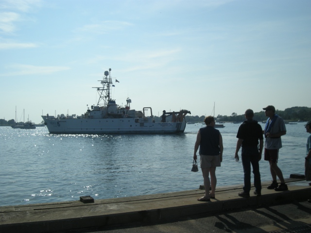
A small group assembled on the dock in Woods Hole, MA, as the ship set sail for its month long cruise in the Gulf of Mexico. (Photo by Shelley Dawicki/NOAA)

The cruise is expected to last a month.  Captain Steve Wagner expects a calm transit to Florida given the seven-day weather forecast.

Final Day for the Aeriel Survey Team

Our surveys took us out to The Deepwater Horizon today. We completed a sawtooth survey (our path made a zigzag shape) criss crossing over the source and covering the area well east and west of the site.

We saw a large pod of 200-250 pantropical dolphins, as well as several smaller groups to the west of the source, 5 sperm whales, a small group of Risso’s dolphins, and some unidentified sharks.

Jen Gatzke in a NOAA57. Photo by Pete Duley/NOAA

We were hoping to jump on NOAA46 this afternoon for a look at the high altitude multispectral imaging, but their afternoon flight was canceled because of a shift in oil spill response efforts. This was our last flight on this round of surveys, and the surveys will pick up again on or about June 28th. Tonight is our farewell dinner with the science crew and pilots from both teams, and we will be heading back to Hyannis, MA, tomorrow morning. We’ve enjoyed our stay in the Gulf and want to thank the good people of Alabama for all their fine hospitality…and their delicious peaches.

~Submitted by Jen Gatzke and Pete Duley

Aerial survey crew. From left: Pete Duley, Jen Gatzke, Lisa Belskis, Carrie Horton, Kevin Barry, Mark Nelson, Tanner Sims

Another Update from the Aerial Surveys in the Gulf

Pete Duley, Carrie Horton, Kevin Barry on board the NOAA57 for an aerial survey of the eastern Gulf of Mexico. (Photo by Jen Gatzke/NOAA.)

On our fourth day, Agent Sims (a.k.a Tanner Sims) and the scientists explored the Dauphin Island Sea Lab Estuarium to learn about their efforts in the Oil Spill Response. Those interested in volunteering in the Mobile Alabama area may contact mobilebaykeeper.org more information. Volunteers will need hazardous material training if they are to be handling oiled wildlife or materials. We do not have such training, so we did not clean any birds yesterday, but we did pick up some delicious peaches at the farm stand which we all enjoyed on NOAA57 today.

Today’s surveys led us into the blue water of the eastern gulf where Bryde’s whales might be expected – because neither Jen nor Pete had ever seen this species, we were very excited. We started along the Alabama and Florida border and moved east on 75 mile north/south lines. Sightings included a pod of 100 Risso’s dolphins (and several smaller groups), 34 Atlantic spotted dolphins, many groups of bottlenose dolphins, several loggerhead sea turtles and a Kemps ridley sea turtle, Bull sharks, eagle rays, Hammerhead sharks, a billfish. Kevin saw two large whales he suspected may have been sperm whales, but we did not break for them.

~Submitted by Jen Gatzke and Pete Duley