May the Weather Be With You

June 4, 2019

The oft quoted line “May the force be with you” should be paraphrased as “May the weather be with you” for our now almost completed spring Ecosystems Monitoring Survey!  We have been blessed by calm seas and light winds for almost every day of this trip, and as a result have now completed sampling coverage on all of Georges Bank and nearly every station in the expansive Gulf of Maine area as well.

Scientific Seawater Analysis System rd

The scientific seawater analysis system on this cruise includes sensors to measure carbon dioxide (NOAA), total alkalinity (UNH), optical properties (URI), and record imagery of phytoplankton (WHOI). All this data is gathered from surface water pumped in along the entire cruise track. Photo credit: NOAA Fisheries/Jerry Prezioso

As mentioned in previous updates, the Ecosystem Monitoring Surveys attempt to serve as a vehicle for collecting data on many different fronts, from plankton to hydrography to seabirds and marine mammals, ocean water chemistry and optical properties, educational outreach and testing the efficacy of collecting gear.

Observers rd

Above:  Observers John Loch and Nick Metheny spent hours everyday on the flying bridge of the Henry B. Bigelow. Their observations of seabirds and marine mammals were interrupted only by fog banks, not bad weather! Right:  Bigelow crew members Aaron Walton and Stephen Crawford deploy a ring net plankton sampler. Photo credits: NOAA Fisheries/Jerry Prezioso

RingNetAaronSteve rd

This cruise, aided by good weather and a unique combination of scientific staff and equipment, has succeeded on all these fronts, and will return home with loads of data and samples collected during our sixteen days at sea.

However, behind the scenes there is another component to the scientific achievements of this cruise: the often unheralded support provided by the vessel and its crew.  Working together, the NOAA officers, engineers, deck crew, survey and electronics specialists all collaborate to make the Henry B. Bigelow the best platform possible for achieving its scientific mission.  Without them the scientists couldn’t accomplish their around the clock, 24/7 routine of data collection in the relative comfort of what can often be a very inhospitable environment; the open ocean.

HB1902 Danielle Mission Control rd2

Survey tech Danielle Power monitors output from sensors during a CTD Niskin bottle water cast. Photo credit: NOAA Fisheries/Jerry Prezioso

Even spending Memorial Day weekend aboard on this cruise away from family and friends was made less of a burden by the efforts of the stewards to create a sense of community with their chili nacho nights,  ice cream socials on Sundays and smoked beef brisket and pulled pork dinners made with their own on-board smoker!

Ray & Dennis in Galley ed rd

Stewards Dennis Carey and Raymond Burgess in the galley of the Henry B. Bigelow preparing one of their many excellent meals! Photo credit: NOAA Fisheries/Jerry Prezioso

Together with the rest of the scientific staff I’d like to thank everyone aboard the Henry B. Bigelow for enabling us to come home not just with a lot of data and samples, but also some fond memories and experiences from our time at sea.  Thank you all very much!

Jerry Prezioso
Chief Scientist
HB1902 Spring Ecosystem Monitoring Survey

Bongos, Barnacles and Boyle’s Law

May 29, 2019

Today marks one week into the voyage of the Henry B. Bigelow Spring Ecosystem Monitoring Survey, also known as EcoMon, and we have covered a lot of ground, literally, since our last update.  Now we have completed 60 stations as we move onto Georges Bank for the northern portion of our survey.  Aided by very good weather, we’ve been able to make good progress, and the sampling has proceeded smoothly with no stations missed from our truncated cruise plan.

Our plankton catches have been light, unencumbered by any algae blooms, thankfully unlike our plankton tows from last fall which were often dominated by dense blooms of a diatom, Thalassiosira mala, that coated our nets with a green mesh-plugging slime!

Thalassiosira mala

Scanning electron micrograph of the diatom Thalassiosira mala that bloomed off the coast of Southern New England in the fall of 2018. Photo credit: Dr. Lucie Maranda, URI/GSO

Fish larvae from the Mid-Atlantic Bight and Southern New England waters have been sparse.  We have a student on board, Quentin Nichols, who has been retrieving fish larvae from one of the bongo plankton nets, but has met with only modest success from the tows he has examined in the southern part of the survey.

Quentin Micro rd

Quentin Nichols from the NEFSC’s Narragansett Lab at his microscope aboard the FSV Henry B. Bigelow. Photo credit: NOAA Fisheries/Jerry Prezioso

Quentin Flatfish2

A flatfish larva collected from the bongo plankton sampler by Quentin Nichols. Photo credit: NOAA Fisheries/Quentin Nichols

Sometimes we do encounter rather unusual “planktonic” finds.  One tow had two colonies of gooseneck barnacles which had attached themselves to two fragments of buoyant plastic that were scooped up by our bongo nets.  It was ironic to find pieces of plastic, one of today’s greatest threats to the ocean ecosystem, providing a habitat for some organisms.

Gooseneck barnacles2 rd2

Gooseneck barnacles collected from the bongo nets. Photo credit: NOAA Fisheries/Jerry Prezioso

Ecosystem monitoring cruises from the Oceans and Climate Branch of the Northeast Fisheries Science Center collaborate with other institutions to conduct joint research while underway.  In addition, there is often an outreach component, usually in the form of a NOAA Teacher-at-Sea candidate who will sail with us to assist in deploying gear and recording data.  In our case a teacher wasn’t available to join us, but we do have representation from some young students in the form of hand-decorated Styrofoam cups.

HB1902 CUPS & Tamara

Tamara Holzwarth-Davis from the NEFSC’s Woods Hole Laboratory holds a mesh bag full of Styrofoam cups from 4th graders at Springbrook Elementary School. Photo credit: NOAA Fisheries/Jerry Prezioso

Fourth graders from the Springbrook Elementary School in Westerly, Rhode Island, have given us 60 of these cups to take out to sea.  Placed in a mesh bag and attached to our Niskin bottle rosette, they will provide an excellent

DCIM100GOPROGOPR2139.

Anthony Johnson and Jonathan Harvey retrieve the Niskin bottle rosette sampler with attached yellow mesh bag full of Styrofoam cups. Photo credit: NOAA Fisheries/Jerry Prezioso

demonstration of Boyle’s Law for the students as they shrink from repeated submersion with the sampling array as it’s lowered to the sea floor to collect water samples and hydrographic data.  These cups, now already a fraction of their original size, will be returned to the students after we disembark on June 6 as mementos of their class’s sea-pressure project!

HB1902 May29 TRAK2 rd

Cruise track of the HB 1902 EcoMon Survey as of the morning of May 29, 2019. Photo credit: NOAA Fisheries/Jerry Prezioso

Now with one week left to this survey we are planning a route that will take us across Georges Bank and through the Gulf of Maine, sampling as many stations as we can reach in the time remaining.  What has been unusual compared to surveys at other times of the year is that the weather has been consistently good, and is forecast to remain so for the near future, which certainly makes planning a lot easier!
Jerry Prezioso
Chief Scientist
HB 1902 Spring Ecosystem Monitoring Survey

From fish to plankton, hydrography and water chemistry

On a sunny afternoon on May 22 at 1400 hours, the FSV Henry Bigelow set sail from Naval Station Newport to embark on the 2019 Spring Ecosystem Monitoring Survey, conducted by the Oceans and Climate Branch of the Northeast Fisheries Science Center (NEFSC).  As is typical for these surveys, there are a number of objectives. Eight scientists are aboard from several different disciplines, conducting a variety of missions to collect data and samples from the shelf waters off the northeast U.S. coast.

HB 1902 Bigelow2 rd

FSV Henry B. Bigelow at Pier 2 of Naval Station Newport, just prior to sailing. Photo credit: NOAA Fisheries/Jerry Prezioso

Unlike the bottom trawl surveys, where the focus is on processing fish from the trawl catches, here we are concentrating on plankton sampling, hydrography and water chemistry, so the fish lab has become our storage area, while the CTD and chemistry labs are packed with a variety of analytical equipment and computers.  Quite a change for the vessel!

HB1902 Wetlab Storage3 rd

The Bigelow Fish Processing Lab has become the storage area for sampling gear and supplies. Photo credit: NOAA Fisheries/Jerry Prezioso

Now, on our third day of the voyage, we have completed fifteen stations, collecting plankton samples south of Narragansett Bay and west and south towards the coast of New Jersey with our bongo nets.  All along the cruise track water is being continuously pumped into the CTD lab and sampled and analyzed for CO2 levels, total alkalinity and optical properties, while video images of phytoplankton in the water are being recorded.

HB1902 CTD Lab Kyle rd

The CTD Lab on the Bigelow is now also filled with a variety of analytical equipment to monitor CO2, total alkalinity, optical properties and record images of phytoplankton from the seawater that is pumped in by the Scientific Seawater System while the ship is underway. Photo credit: NOAA Fisheries/Jerry Prezioso

DCIM100GOPROGOPR2129.

Deck hands Lindsey Houska (right) and Aaron Walton retrieving the plankton bongo nets after a sampling tow. Photo credit: NOAA Fisheries/Jerry Prezioso

The trip was punctuated with a previously scheduled calibration of the vessel’s computer-controlled Dynamic Positioning System, which automatically maintains a vessel’s position and heading by using its own propellers and thrusters, in Narragansett Bay. It took up a large part of our second day, but the command and crew are working hard to make up for that time.  We are now running smoothly on a course which should take us just beyond Delaware Bay for the southern portion of this trip. Good weather is helping too!

Jerry Prezioso
Chief Scientist
HB 1902 Spring Ecosystem Monitoring Survey

Merging Science and Technology at Sea

Science and technology come together to execute the Spring Bottom Trawl Survey onboard the NOAA Ship Henry B. Bigelow.  Gone are the days of pencil, paper, and tally marks to record data collected at sea.  Various methods are employed to ensure efficient, accurate and rapid recording of not only biological data but also ship sensors, position, and performance of protocols.

Where the ship, nets, and other data devices are located and collecting information in the Northeast Atlantic Ocean both spatially and vertically in the water column are recorded (see images below).  This provides the NOAA Corps Officers, the Chief Scientist, and Watch Chiefs with data graphically displayed via many different screens.

springbts-leg4-technology

Pictured top left:  sonar track of the Bigelow over bottom topography; right: spatial location of the vessel and one of the stations; bottom left: vertical sensors on the trawl net, with the orange line showing the net being recovered aboard ship.  Photo credit:  NOAA Fisheries/Heidi Marotta


While working up the specimens collected in the net, technology provides the solution with barcoding.  Species are sorted into barcoded baskets, buckets and pails and recorded into the database via the FSCS2 (Fisheries Scientific Computing System 2.0) software by the Watch Chief.  Accurate weights are calculated and stored automatically.  As samples move down conveyor belts to the scientific crew for workup, they are pulled off the belt and scanned with waterproof barcode scanners.  The software then displays the species for confirmation and sampling begins.  As physical samples are prepared (freezing partial or whole specimens, or removing otoliths used for aging fish), a barcode printer at each sampling location instantaneously prints a waterproof label for the bag or envelope.  These samples are placed into a big walk-in freezer or into bins on the wall of the wet lab.

630229FE-1464-4949-941C-0D24D1EBA1CB

Barcodes rule!  Top left:  The container barcode is assigned to a specific species and scanned into the FSCS2 program to open up that species sampling protocol. Top right: barcoded labels are printed for and attached to all samples that are collected at sea. Note the specific details on the label.  Bottom: Bins holding otolith samples. Other samples that may be barcoded are stomach contents, reproductive samples, and whole fish and invertebrates sent back for identification, research,  or training purposes. Each envelope has a barcode label noting the common name and the scientific name for the species, along with a lot of other information. Photo credit: NOAA Fisheries/Heidi Marotta


Electronic, motion compensated scales weigh in containers, individual fish and electronic measuring boards record weight and lengths respectively, at the touch of a button or a touch of a magnet sending the data to the server.  These data are audited real time (using known algorithms for species length/weight calculations, for example), ensuring immediate at sea correction so that when the survey is complete the data is readily available soon after.

The wet lab where the biological data are collected is a harsh environment with flushing water constantly running, scientific crew dressed in foul weather gear and big blue rubber gloves, in addition to large amounts of wet, slimy, fish. Touch screens are the main interface to the science crew to record observed characteristics of specimens such as sex, maturity, and stomach contents.  All of the technology in this area is rugged, waterproof, reliable and interacts with the software and database to quickly and accurately save the data.

430EA1FE-C954-49ED-BDEE-21402CAAEE93

Top : screen shot of a FSCS2 protocol screen.  Bottom Right: a fish on the measuring board, with measuring magnet visible at far right.  Bottom left:  scale screen showing specimen weight. Data from the electronic scale and the measuring board (right) are all recorded into the database. (Photo credit: NOAA Fisheries/Heidi Marotta


At the end of the two and a half month survey the final physical specimens are offloaded to be brought back to the NEFSC’
s Woods Hole Laboratory for land-based processing.  The database with the sensor data and biological data is exported onto a thumbdrive to be loaded onto the servers back at the lab for scientific analysis.  The barcodes allow for individual specimen identification in the database when scanned by other land-based software applications.  Where the specimen was collected, the temperature of the sea water, and all of the individual measurements are available for scientific use.

When asking the crew out of this final leg of the spring survey if they could imaging collecting data any other way than with sophisticated computer technology, they all answered with a resounding “No way!” (at least not the volume, speed, or accuracy).  Granted the majority of this crew grew up on video games, personal computers and cell phones, so they fully trust in all things computer and technology related to make life easier and information more accurate.  As a computer scientist responsible for providing these solutions, I couldn’t agree more!

Heidi Marotta
IT Specialist, NEFSC
Acting Data and Development Branch Chief
Aboard the FSV Henry B. Bigelow
Spring 2019 Bottom Trawl Survey Leg 4

Sei Whale Soup, and a few right whales

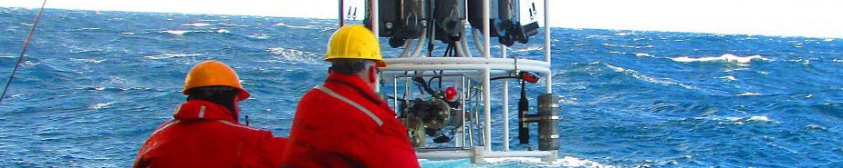
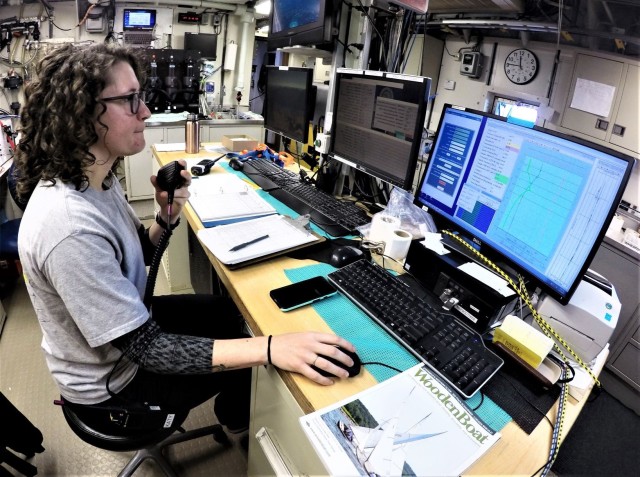
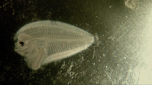
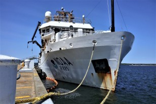
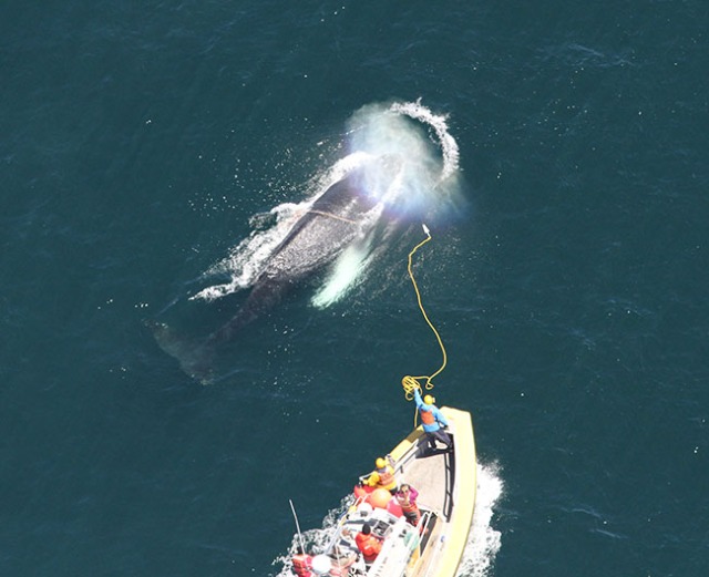
The 2019 spring right whale cruise is being conducted aboard the University of Connecticut’s research vessel Connecticut, which is a 90-foot vessel proving to be a very nimble and capable vessel for this work. We departed Woods Hole on Monday, May 6, around 6pm, arriving in an area south of Martha’s Vineyard  and even south of the New York shipping lanes by daylight Tuesday morning. The weather was good and the NEFSC aerial crew came out in the NOAA Twin Otter to survey in the same area. They relayed positions of two groups of right whales, each a group of two. We traveled to the first group and found one right whale in that area. Conditions were not good for launching the small rigid-hulled inflatable boat, or RHIB, but with the help of Pete Duley’s 500mm lens, we managed identifiable images from the fly bridge of the ship. We then headed west to the second location, where we again found one right whale.

pete-duley

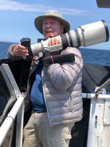
Pete Duley with his 500mm lens. Photo credit: NOAA Fisheries/Elizabeth Josephson

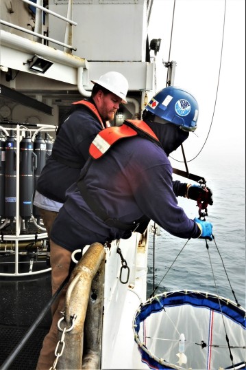
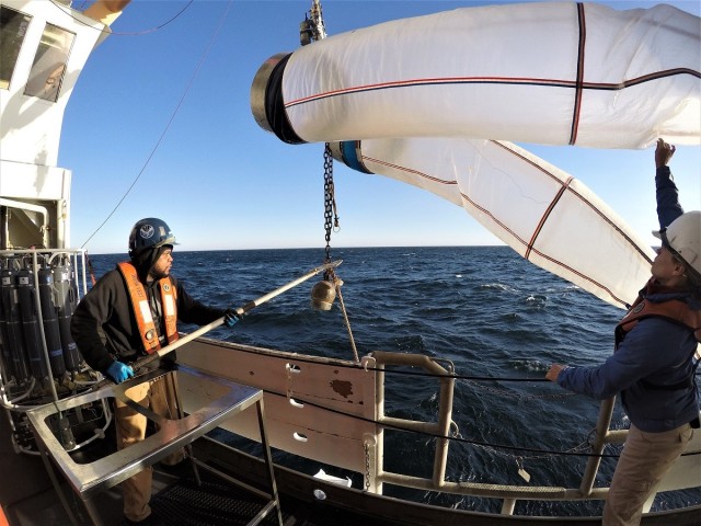
The next morning, Wednesday the 8th, we were set up a few miles to the west of the aerial team’s last sighting from the 7th. Conditions were calm and we set up a boxed survey around an area where five right whales had been seen. As we worked our way east of the original sighting, we came upon several small groups of sei whales. They were all skim feeding. Obtaining sei whale biopsy samples is a secondary objective of this cruise. We decided to launch the RHIB and get some biopsy samples. As fieldwork often goes, by the time we launched, the sei whales were no longer skim feeding and the seas began to pick up.

After some effort to keep up with sub surface feeding sei whales (we don’t recommend that you try this at home!) we brought the RHIB back onboard…..er, just in time for Genevieve Davis to call from the fly bridge with a right whale sighting! Whaaaat?!? Again, we were able to photograph from the fly bridge.

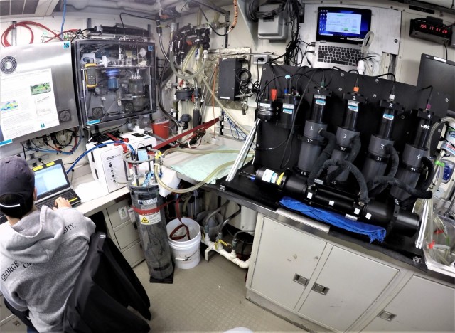
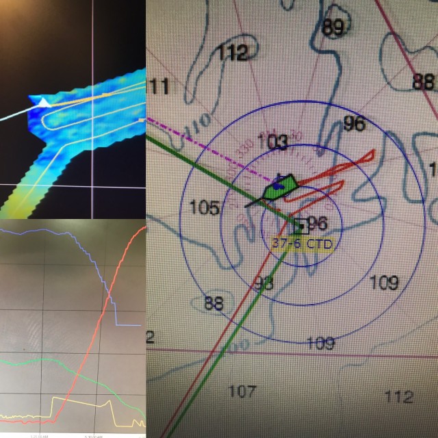
Unfortunately, we couldn’t relaunch again in these seas. We photographed three right whales from the ship this day. By the end of the day, we were not far from where we’d started and decided to deploy a prototype hydrophone buoy that Chris Tremblay is testing in collaboration with Melissa Omand from URI. The hydrophone is set at 30 meters on a weighted cable from a float that is tracked using Iridium, SPOT GPS, and the Automatic Identification System (AIS) . We deployed the buoy and drifted most of the night not too far away. The ship was able to track the buoy easily with AIS up to six nautical miles away.

right-whale-from-rv-ct-5944

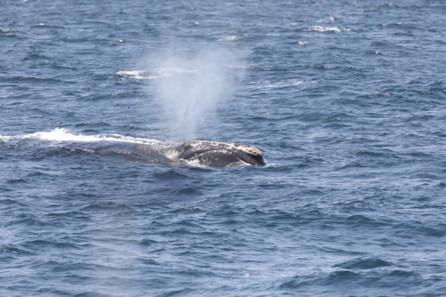
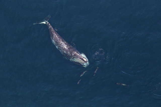
North Atlantic right whale photographed from the R/V Connecticut. Photo Credit: Amy Warren

On the morning of the 9th, we were again in calm seas and the buoy was only about four miles away. We decided to re-survey the area during the morning. With no whales sighted, we returned to pick up the buoy and continue surveying to the north where the plane reported a group of three to five whales on Tuesday. Buoy retrieval was successful and done before the seas picked up. The buoy was deployed overnight. We headed north to survey, finding another two right whales. One of them was ID’d as biopsy target, Eg#3297. Seas are too rough to launch. Interestingly, this whale was seen in Cape Cod Bay in April. One of the right whales was exactly in the shipping lanes with four ships inbound! We called the U.S. Coast Guard, Long Island sector and requested a Broadcast Notice to Mariners. They complied without question, all very good. By nightfall, we were heading into Woods Hole to run from weather and to let Chris and Genevieve troubleshoot some components of the sonobuoys. We snuck into Woods Hole around 2am, and were at the NEFSc’s Woods Hole Laboratory dock  almost all day.

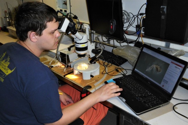
Some notes about the waters surveyed on May 7th – 9th: There is a LOT of fishing gear out here! With a lot of feeding whales around. The aerial surveys have been documenting whales in this area for some time now. There also seems to be a good bit of Calanus here. We’ve done five bongo tows near feeding whales, all producing good catches of Calanus. Most exciting is that Leah Crowe had identified all of our right whales and two of them are VERY interesting! One is #1145 (also known as Grand Teton), who to the best of our knowledge has not been seen since 2010 and another is #1950, who to the best of our knowledge has not been seen since 2015. We believe that neither of these whales were seen in Cape Cod Bay this spring. Both are adult females with a calving history.

On May 11th, we headed out into the Great South Channel (GSC). The NEFSC aerial team surveyed there on the 9th and found no whales. Since it was the only area with any workable weather, we decided to head out and sample for zooplankton at some of Mark Baumgartner’s historical sampling stations…back when right whales actually came into GSC in May. Our samples were interesting in that they consisted of mostly slimy sludge (science speak from someone who only looks at mega fauna), little discernable Calanus, some jellies, and a few other invertebrates. The slimy sludge was near impossible to clean off of the bongo nets. Chris and Gen deployed one sonobuoy and heard a couple of sei whale down sweeps. After dissecting weather forecasts very meticulously, Captain Marco agreed to head to George’s Bank overnight!

On May 12th, we awoke on George’s Bank to fairly good sea conditions….and rain. We knew stormy weather was coming, so were fairly judicious with our time. We began to survey, watching from the ship’s bridge. Gen and Chris deployed another sonobuoy in a location that we’d come near again on the next track line. They heard sei and humpback calls. Around 1300hrs, we got into sei whale soup! Spectacular sight with sei whales skim feeding, surfacing in every direction, oh, and there are a few humpbacks mixed in …..and wait for it….there’s a right whale! We did our best to get close to the right
whale. It was fluking about every nine minutes, so feeding deeper. We had rain and fog and sei soup. We never got close to the right whale. As we tried to leave the area and continue on our track we got into another area of sei whales, and yes, found another single right whale. Sea conditions were holding for us nicely, but we knew we had to make a dash back to Nantucket Sound, at 10 knots. Gen and Chris heard sei, humpback, and probable right whale calls on a sonobuoy deployed near the first aggregation.
Both common and white-sided dolphin were also seen and heard.

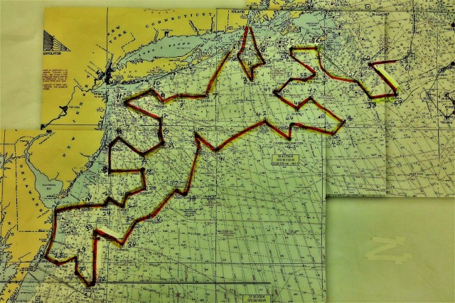
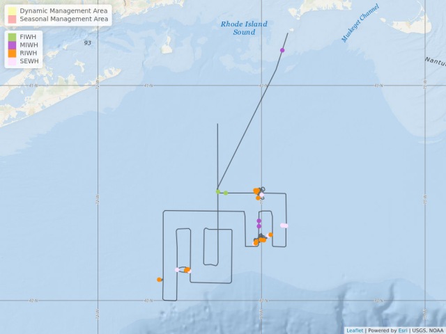
We are currently headed to Avery Point, CT, the ship’s home port, to take on fuel and hide from this weather. See map below for overview of our efforts to date.

RWcruiseMapthru12May2019

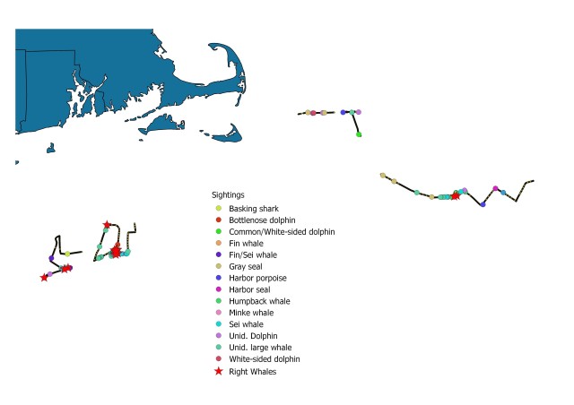
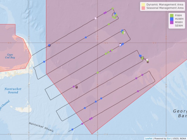
Map showing location of marine mammal sightings through May 12, 2019. Image credit: NOAA Fisheries/Elizabeth Josephson

Lisa Conger
Aboard R/V Connecticut
Spring 2019 Right Whale Cruise

Lots of Humpbacks and Fins

Although no North Atlantic right whales were sighted during the NEFSC’s aerial whale survey on May 9 east of Cape Cod in the Great South Channel, observers aboard the NOAA Twin Otter aircraft saw 34 fin whales, 53 humpbacks, 10 minke whales, and 6 sei whales.

may9-aerial-report-map.jpg

This may be the last flight for the Twin Otter until June 1, when NEFSC aerial survey operations head north to help survey Canadian waters as whales continue to migrate into the Gulf of St. Lawrence.

The NEFSC Aerial Survey Team


Whales Are Migrating

NEFSC scientists sighted two fin whales, three minke whales, 15 right whales and 13 sei whales during an aerial whale survey flight May 7 in Rhode Island Sound.

A Dynamic Management Area (DMA) established southwest of Martha’s Vineyard has been extended through May 21 to protect an aggregation of four North Atlantic right whales sighted on May 7 during the flight in a NOAA Twin Otter aircraft.

NOAA Northeast Region Right Whale Aerial Survey Report

Seasonal Management Areas (SMAs) are in effect in Cape Cod Bay through May 15 and in Great South Channel through July 31.

An exploratory survey south of Nantucket was opkanned for today.


The NEFSC Aerial  Survey Team


Spring 2019 Longline Survey Off to a Good Start

F/V Tenacious II and F/V Mary Elizabeth returned to port on May 2 and May 3, respectively, from their second trips of the Cooperative Research Branch’s spring bottom longline survey in the Gulf of Maine. The vessels have been staffed by Dave McElroy, Giovanni Gianesin, Dominique St. Amand, Elizabeth Marchetti, and Calvin Alexander for the first two trips.

Collectively, both vessels have sampled 19 stations, with 11 of the stations located in
the Western Gulf of Maine and the other 8 stations in the Eastern Gulf of Maine.
Eighteen of the sampled stations have been rough bottom (rocky bottomed) and
the other smooth bottom (sand/mud bottom).

cusk-holding-tank mbl-brodet

Cusk in a holding tank at the Marine Biological Laboratory. Photo credit:  NOAA Fisheries/Alison Brodet

Live fish were retained by both vessels from their first trips for the Northeast Fisheries Science Center’s Woods Hole Science Aquarium. Atlantic cod, cusk, haddock, pollock, wrymouth, longhorn sculpin and thorny skate were collected and handed over to Alison Brodet from the aquarium.

fish-holding-tank-mbl-brodet

Pollock, haddock, longhorn sculpin and thorny skate in holding tank at the Marine Biological
Laboratory, Wood Hole. Photo credit: NOAA Fisheries/Alison Brodet

The catch in the Western Gulf of Maine consisted of haddock, cusk, Atlantic wolffish, Atlantic halibut, red hake, thorny skates and spiny dogfish. Eastern Gulf of Maine stations produced catches of Atlantic halibut, haddock, Blackbelly rosefish, cusk, pollock, Atlantic cod, white hake and spiny dogfish. A 200 lb. Porbeagle shark was also caught, tagged and released at one the eastern stations. What could possibly be the largest cusk ever encountered in the history of the longline survey was caught on F/V Mary Elizabeth. It measured 99 cm (about 39 inches) long!

record cusk

The record-breaking cusk was measured at 99 centimeters or about 39 inches long. Photo credit: NOAA Fisheries/Dominique St. Amand

The teams are headed back out at sea for the weekend. Stay tuned to see what they catch next!

Calvin Alexander
Northeast Cooperative Research Program


The Science of Whale Protection

large whale photographed from above while swiming near the ocean surface

Free-swimming North Atlantic right whale photographed during 2016 NOAA Fisheries aerial survey. Photo credit: NOAA Fisheries/NEFSC/Allison Henry

On a Mission

Part of the NOAA Fisheries mission is to conserve and recover protected species while supporting responsible fishing and resource development. But what happens when forging ahead on one part of this mission seems to mean falling behind on another?

Case in point: endangered North Atlantic right whales and the Northeast’s American lobster fishery. These rare whales are losing ground after two decades of slow recovery; a major cause of death among adults in the population is entanglement in trap/pot gear, most of which is set in the American lobster fishery.

The stakes are high and humble me. The law requires us to recover North Atlantic right whales and to support sustainable trap and pot fisheries. My job – and the Northeast Fisheries Science Center’s job – is to provide the science to support both of these requirements.

It Takes a Team

If protecting whales and supporting fishing were easy, it would not need an intense effort to find solutions. Fortunately, a large team of people with a shared concern for the well-being of whales and fisheries is hard at work on the problem.

This team – called a Take Reduction Team – is required under federal law (the Marine Mammal Protection Act) in situations just like this one: when a commercial fishery poses a high risk to a marine mammal. It’s a way to bring people with fishing, fisheries, and marine mammal knowledge and skills together to find solutions.

whale disentanglement

NEFSC aerial survey team photograph of a large whale disentanglement response. Photo Credit: NOAA Fisheries/NEFSC

The Science of Risk Reduction

In October 2018, the team asked for better decision-making tools.  Responding to this request, scientists at our science center got to work.  Across our research divisions, people applied our expertise, data, modeling skills, and capacity for visualizing data to get insights about the interplay of whales and fishing in ways that were out of reach just a few years ago.

The result of that work, I am pleased to report, is an important new tool that supported the team as they developed a set of proposed actions for pot and trap fisheries to substantially reduce the risk they pose to right whales.

Last week, the take reduction team came together in Providence, Rhode Island, in an intensive four-day meeting to craft ways of reducing risks posed to right whales by lobster gear across the region.  This new tool helped team members evaluate just how much risk reduction was likely under various scenarios, based on the likely presence of gear and whales in an area, and how seriously the gear could injure a whale.

Take reduction team members took that information, asked for more, and worked through numerous options specific to each lobster fishing area. Center scientists were on hand during the meeting to add more information and to use the tool in real-time as team members refined their plans.

Next steps for us are to review this work and to make the tool better.

The team’s work last week is a great example of true collaboration, both within our science center and among the people working toward solutions to a tough problem, and one of which we can be proud.

Jon Hare

NEFSC Science and Research Director


Easter on Georges Bank and Northeast Channel

During Easter weekend, we were sampling along the northeastern part of Georges Bank and even made it into Canadian waters.  We’ve been seeing a lot of large winter skate, Leucoraja ocellata.

pic 1-winter skate

A winter skate on the measuring board. Photo credit: NOAA Fisheries/Christine Kircun

This species may be confused with little skate, but at these sizes, there’s no dispute.  It’s not uncommon to see a winter skate measure in at over a meter long!  At that size, some caution is needed when handling this bottom dweller because it has very sharp dermal denticles on its wing.  Dermal denticles are tough, and in this case, extremely pointy, scales that help with protection.  As I was sorting fish, my Grundens (waterproof outerwear) got snagged onto some of these denticles and nearly caused a tear!

The fish tend to get bigger the further north we go.  We caught some sizable fourspot flounder, Paralichthys oblongus, that were over 40cm.

pic 2-fourspot flounder

Fourspot flounder. Photo credit: NOAA Fisheries/Christine Kircun

This one was the largest one I remember seeing at 50 cm!  Their characteristic four spots are easy to see and with their large mouths, it’s not uncommon to find fish, shrimp and crabs in their stomach.

A yellowfin bass, Anthias nicholsi, was caught during the day shift. Its neon yellow and pink colors definitely catch your eye among the more brown and muted colors commonly found in the area.

yellowfin bass

Yellowfin bass. Photo credit NOAA Fisheries/Christine Kircun

And just for fun, we had an egg decorating contest. After the eggs were decorated, we were able to cast our votes. It wasn’t easy because there were so many fun and creative eggs, but there were some that stood out.
pic 4-egg contest

Congratulations to Katelyn Depot for ‘Best Overall Egg’ (#14), Joseph Warren for ‘Most Traditional Egg’ (#15), and Jakub Kircun for ‘Most Creative Egg’ (#1)!

Christine Kircun
Aboard the FSV Henry B. Bigelow
Spring 2019 Bottom Trawl Survey Leg 3